In chapter 4, you were introduced to some of the phenomena related to volcanoes
and volcanic activity around the world. You learned that the eruptive behavior
of volcanoes is related to aspects of the chemical composition of magmas -
and the chemical composition of magmas varies with respect to plate tectonic
setting.
These fundamental principles of volcanoes and volcanic processes were vividly
illustrated for North American geologists and others worldwide during the
catastrophic eruption of Mt. St. Helens in May 1980. Even though geologists
knew Mt. St. Helens had a long eruptive history, prior to 1980 the volcano
was in a dormant state; it had not erupted since 1857.
During the eruption, the summit of Mt. St. Helens lost nearly 400 m as this
material was erupted skyward or blasted laterally toward the north. The gaping
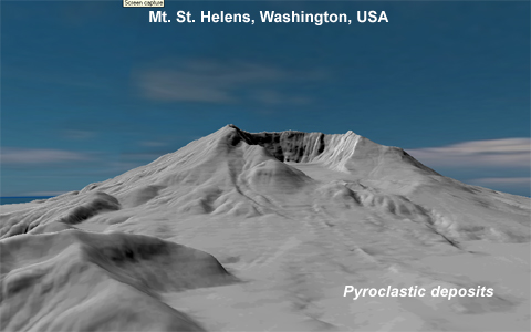
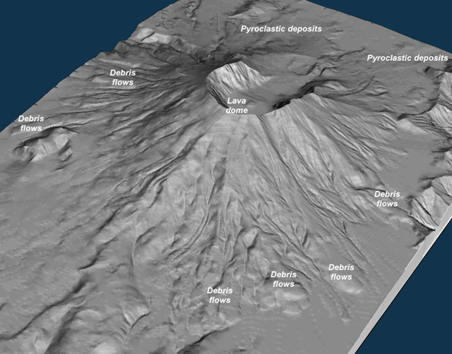
crater remains as evidence of the power of this eruption. The images on this
page are computer-generated views of the volcano derived from a digital elevation
model (DEM) of the mountain created following the 1980 eruption.
 <a onClick="window.open('/olcweb/cgi/pluginpop.cgi?it=jpg:: ::/sites/dl/free/0072402466/30425/VirtualVista0401.jpg','popWin', 'width=NaN,height=NaN,resizable,scrollbars');" href="#"><img valign="absmiddle" height="16" width="16" border="0" src="/olcweb/styles/shared/linkicons/image.gif"> (73.0K)</a>
The image above is a view from the northeast, looking into the crater. The
broad apron extending outward from the entrance of the crater is composed
of pyroclastic debris erupted from the mountain during the cataclysmic eruption
of 18 May 1980 and smaller eruptions that emanated from the crater during
the years following 1980.
The image below is from the southeast looking over the crater rim. This view
shows a number of large debris flows on the flanks of the volcano. Much of
this debris moved downslope during the eruption as the snow and ice mantle
of the mountain melted and mixed with volcanic ash and debris to form lahars
(volcanic mud flows) that streamed outward from the mountain for many miles.
Additional debris flows occurred in the years following the eruption as the
denuded slopes were subjected to heavy rainfall. Devoid of vegetation, the
barren slopes easily became saturated with water and slid down hill under
the influence of gravity.
 <a onClick="window.open('/olcweb/cgi/pluginpop.cgi?it=jpg:: ::/sites/dl/free/0072402466/30425/VirtualVista0402.jpg','popWin', 'width=NaN,height=NaN,resizable,scrollbars');" href="#"><img valign="absmiddle" height="16" width="16" border="0" src="/olcweb/styles/shared/linkicons/image.gif"> (195.0K)</a>
At the center of the crater, a large dome of lava has slowly extruded from
beneath the volcano, and continues to grow slowly each year. Geologists expect
this lava dome will eventually rebuild the volcano to something resembling
its pre-1980 dimensions.
A wealth of additional information on Mt.
St. Helens (both before and after the 1980 eruption) is available from
the United States Geological Survey's Cascades
Volcano Observatory.
Follow the link above to learn more about this fascinating volcano.