(See related pages)
Should We Revise the 1872 Mining Law? What do you think? Should We Revise the 1872 Mining Law? In 1872, the U.S. Congress passed the General Mining Law intended to encourage prospectors to open up the public domain and promote commerce. This law, which has been in effect more than a century, allows miners to stake an exclusive claim anywhere on public lands and to take-for free-any minerals they find. Claim holders can "patent" (buy) the land for $2.50 to $5 per acre (0.4 hectares) depending on the type of claim. Once the patent fee is paid, the owners can do anything they want with the land, just like any other private property. Although $2.50 per acre may have been a fair market value in 1872, many people regard it as ridiculously low today, amounting to a scandalous give-away of public property. In Nevada, for example, a mining company is buying federal land for $9000 that contains an estimated $20 billion worth of precious metals. Similarly, Colorado investors bought about 7000 ha (17,000 acres) of rich oil-shale land in 1986 for $42,000 and sold it a month later for $37 million. You don't actually have to find any minerals to patent a claim. A Colorado company paid a total of $400 for 65 ha (160 acres) it claimed would be a gold mine. Ten years later, no mining has been done, but the property-which just happens to border the Keystone Ski Area-is being subdivided for condos and vacation homes. According to the Bureau of Land Management (BLM), some $4 billion in minerals are mined each year on U.S. public lands. Under the 1872 law, mining companies don't pay a penny for the ores they take. Furthermore, they can deduct a depletion allowance from taxes on mineral profits. Senator Dale Bumpers of Arkansas, who calls the 1872 mining law "a license to steal," estimates that the government could derive $320 million per year by charging an 8 percent royalty on all minerals and probably could save an equal amount by requiring a bond to be posted to clean up after mining is finished. On the other hand, mining companies argue they would be forced to close down if they had to pay royalties or post bonds. Many people would lose jobs and the economies of western mining towns would collapse if mining becomes uneconomic. We provide subsidies and economic incentives to many industries to stimulate economic growth. Why not mining for metals essential for our industrial economy? Mining is a risky and expensive business. Without subsidies, mines would close down and we would be completely dependent on unstable foreign supplies. Mining critics respond that other resource-based industries have been forced to pay royalties on materials they extract from public lands. Coal, oil, and gas companies pay 12.5 percent royalties on fossil fuels obtained from public lands. Timber companies-although they don't pay the full costs of the trees they take-have to bid on logging sales and clean up when they are finished. Even gravel companies pay for digging up the public domain. Ironically, we charge for digging up gravel, but give gold away free. Over the past decade, numerous mining bills have been introduced in Congress. Those supported by environmental groups, generally would require companies mining on federal lands to pay a higher royalty on their production. They also would eliminate the patenting process, impose stricter reclamation requirements, and give federal managers authority to deny inappropriate permits. In contrast, bills offered by Western legislators, and enthusiastically backed by mining supporters, tend to leave most provisions of the 1872 bill in place. They would charge a 2-percent royalty, but only after exploration, production, and other costs were deducted. Permit processes would consider local economic needs before environmental issues in this version. What do you think we should do about this mining law? How could we separate legitimate public-interest land use from private speculation and profiteering? Are current subsidies necessary and justifiable or are they just a form of corporate welfare?
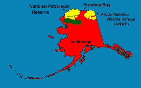
Historic Decision to Allow Drilling in Remote Alaska Oil Reserve July, 1998 On August 6 Interior Secretary Bruce Babbit announced the controversial decision to authorize oil and gas drilling leases in 4 million acres of Alaska's arctic coast. This area is part of the 23 million-acre National Petroleum Reserve in Alaska (NPR-A), identified in 1923 as a reserve for possible development in times of national need. At the same time, Babbit denied leases in the wetland-rich Teshekpuk Lake area of the NPR-A, arguing that the “biological wonderland” should be protected.
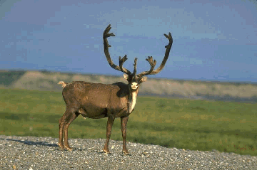
The NPR-A occupies a region of arctic coastline adjacent to Prudhoe Bay, the principal source of the state's oil wealth for over twenty years. The coastal tundra, with thousands of wetlands and small lakes, provides breeding grounds for 5 million migratory birds, representing 90 species, including swans, snow geese, arctic loons, and many arctic coastal ducks. The inland region of the NPR-A is home to Alaska's largest caribou herd, the 450,000-member Western Arctic herd, as well as grizzly bears and wolves. Environmentalists have advocated legal protection for the entire reserve, but some have been willing to consider oil development in a portion of the reserve in exchange for protecting the rest of the region. Development in the NPR-A is hoped to ease pressure to open up the Arctic National Wildlife Refuge to oil development, a proposal that was recently blocked by President Clinton.
The compromise decision followed an 18-month environmental review and comment period, during which Alaska's governor and congressional delegation joined oil companies in urging the NPR-A's opening. The state is eager to see oil development in the region because the Alaskan economy depends heavily on oil revenue, and wells in the neighboring Prudhoe Bay area are beginning to run dry after two decades of pumping. Wetland Area Off-limits At the same time, denying leases in the Teshekpuk Lake area is an important protective measure. Not only are wetlands and lakes irreplaceable breeding grounds, they are also especially susceptible to pollution related to oil development, including leaks in wastewater and chemical storage, in oil pumping, and in pipeline spills and leaks. The oil industry, on the other hand, was disappointed by the August decision to deny leases in the coastal wetland area. The coastal plain is believed the most likely to yield significant amounts of oil. Exploratory drilling could begin this winter. To read more, see Environmental Science, A Global Concern, Cunningham and Saigo, 5th ed.
Environmental Science, Enger and Smith, 6th ed. For further information, see these related web sites: Environmental Impact Statement information, Bureau of LandManagement
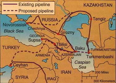
Twice in four years, Russian troops pounded the rebellious province of Chechnya with bombs, rockets, and artillery in a war they can ill afford and probably never win conclusively. Why such a ferocious assault on a tiny, impoverished state at the fringes of their former empire? The answer is that Chechnya is the gateway, for Russia, to what may be one the world's richest reserves of oil and natural gas around-and under-the Caspian Sea. It has long been known that Central Asia is rich in oil. Marco Polo wrote in the fourteenth century of "fountains from which oil springs in great abundance." An oil boom a century ago turned Baku, the capital of Azerbaijan, into a city of instant millionaires. But the Soviet Union never put much effort into developing Caspian oil, preferring to emphasize less politically challenging wells in Siberia. By the 1980s, a crumbling network of leaking pipelines, rusty drilling rigs, decaying cities, and patches of oil-soaked soil around the margins of the Caspian showed the effects of sloppy management and neglect. When the Soviet Union broke apart in 1991, a mad rush began as Western energy companies fought to be the first to exploit what may be the last really big, relatively accessible oil field in the world. Oil deposits around the Caspian Sea are thought to hold up to 200 billion barrels, perhaps 25 percent of all the world's oil. If true, this resource would be worth about $4 trillion at today's prices, or about 30 times as much as Alaska's entire North Slope deposit. In addition, countries neighboring the Caspian are thought to have enormous reserves of natural gas. Turkmenistan alone is thought to sit on 9 trillion m3 of gas, making it the world's fourth-largest holder of this valuable resource. In total, the Central Asian Republics may control a quarter of the world's natural gas supply. The biggest difficulty is how to get these resources to market from their landlocked sources. It doesn't help that the area has some of the worst weather-temperatures ranging from -40°C to +50°C (-40°F to +122°F)-and most bellicose and unstable political climates in the world. Regional players include Russia, Chechnya, Dagestan, Abkhazia, Ingushetia, Ossetia, Kurdistan, Kazakhstan, Turkmenistan, Uzbekistan, Azerbaijan, Armenia, Georgia, Turkey, and Iran. There are more than 60 indigenous languages, and at least as many ethnic feuds in the region. Together in the 1990s, these groups had six major wars, two presidential assissination attempts, two coups, and countless guerrilla and bandit attacks. The shortest-and probably cheapest-route for an oil or gas pipeline from the Caspian is across Iran to the Persian Gulf. The United States adamantly opposed that option, however, both to thwart Iran, and because of the risk of having additional oil passing through the vulnerable Persian Gulf. Russia has campaigned for a route following an existing pipeline northward through Chechnya-explaining why control of this area is so important-and then west to a Russian port on the Black Sea. This would require tankers to pass through the congested straits of Bosporus and the Dardanelles, and would make us dependent on Russia to keep the oil flowing. In 1999, a contract was signed to build a 2000 km (1250 mi) pipeline along the U.S.-preferred route from Baku, across Georgia, and then south across Turkey to the Mediterranean Sea. An extension nearly as long would cross under the Caspian and then run north to the Tengiz oil field in Kazakhstan. Costing at least $4 billion (US), the pipeline will take five years to build, and will carry about a million barrels of oil per day (42 million gal or about 6 percent of U.S. consumption) when finished. Protecting this sprawling network of vulnerable pipelines in a rugged mountainous region of ancient but fierce ethnic, religious, and political hostilities is a daunting prospect. Does this story suggest to you that our dependence on oil creates odd bedfellows and difficult geopolitical problems? How far will we go to ensure our access to energy resources? In this chapter, we will focus on fossil fuels and nuclear power, which together supply about 97 percent of the world's commercial energy. Chapter 22 examines some energy conservation options as well as alternative, renewable energy sources.
FIGURE 21.1 A U.S.-backed oil pipeline is proposed from Azerbaijan through Georgia, and then southwest across Turkey to the Mediterranean. Russia prefers a route across Chechnya to Novorossisk on the Black Sea.
The tiny island-nation of Nauru (pronounced NAH-roo) in the western Pacific is the smallest and most remote republic in the world. It also is a case study in humanity's ability to plunder its environment. Located on the equator some 500 km west of its nearest neighbor in the Marshall Islands, Nauru has been inhabited by Polynesian people for thousands of years. When first visited by European explorers in the eighteenth century, the island was a lush tropical paradise of swaying coconut palms and white coral beaches. Sailors called it Pleasant Island, but today the name is a bitter joke. Compared to its former condition, Nauru is probably the most environmentally devastated nation on earth. So much land has been devoured by strip-mining that residents now face the prospect of having to abandon the whole island and move elsewhere. What the miners sought was guano, a thick phosphate-rich layer of bird droppings prized by industrialized countries as fertilizer. Billions of dollars worth of this treasure have been exported, first by colonial powers and then, since independence in 1968, by the Nauruans themselves. After a century of mining, Nauru's 7500 residents are among the richest people in the world, but their environment has been almost totally wrecked. Eighty percent of the 21 sq km (8 sq mi) island has been stripped, leaving a bleak, barren moonscape of jagged coral pinnacles, some as tall as 25 meters. With all soil washed away, almost nothing lives in this wasteland. Traveling across it is impossible. To make things even worse, removing the vegetation has changed the climate. Heat waves rising from the sun-baked rock drive away rain clouds and the island now is plagued by constant drought. Not only the island is ravaged. Nauruans may be among the world's most affluent people, but they are also among the most unhealthy, plagued by cardiovascular disease, diabetes, and obesity brought about by a lifestyle of idleness and imported junk food. Few islanders live past the age of 60. Since most mining is done by imported workers, Nauruans generally lack job skills to apply elsewhere. This case study is a sad example of how easy it is for modern technology and lack of foresight to degrade both a society and its environment. The guano deposits are expected to last only a few more years. After that, residents will be left with only a thin sliver of habitable coastline. Some efforts have been made to import new soil and to restore vegetation to the desolate interior, but attempts have been unsuccessful. It may be too late to reverse the damage. The people may be able to use some of their accumulated trust fund to buy another island, but will they find one as comfortable and beautiful as what they once had? One village leader says wistfully, "I wish Nauru could be like it was before. I remember it was so beautiful and green everywhere. We could eat coconuts and breadfruit. It makes me cry when I see what has been done. I wish we'd never discovered the phosphate." Could Nauru's example be a warning for all of us? Humans have a long history of depleting resources and then moving on. Could we find ourselves in a similar situation someday, having exhausted our natural resources but then having an uninhabitable world? Ethical Considerations If the Nauruans appeal for help in finding another place to live, would we be morally obligated to assist them? Do countries that bought fertilizer from Nauru bear a special responsibility for what has happened? If we see other examples of environmental destruction occurring elsewhere, would we be ethically justified to try to intervene and stop it?
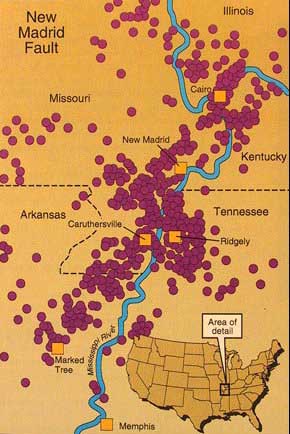
In 1994, a strong earthquake (magnitude 6.6 on the Richter scale) jolted the city of Northridge in the San Fernando Valley just north of Los Angeles and reminded us of the dangers of geological forces. Fifty-five people died, 75,000 were left homeless, and more than 3 million people lost power, light, and heat as buildings crumbled, electric power lines ruptured, and gas lines exploded. Traffic was hopelessly snarled for months afterward because dozens of bridges collapsed and highways snapped like twigs. Repairs are estimated to cost $15 billion to $20 billion. Devastating as this earthquake was, it was not by any means the largest or most catastrophic that might occur. Geologists warn that a really "big one" (greater than 8.0 on the Richter scale) is likely along the sound end of the San Andreas Fault east of Los Angeles. Even more ominous is the likelihood that the Elysian Park fault system which passes directly beneath downtown Los Angeles, could unleash a tremor with ten times the destructive power and hundreds of times as much loss of life and property damage as the Northridge quake. Surprisingly, the West Coast is not the only place in the United States where a geological cataclysm might occur. People who think that earthquakes are strictly a Californian phenomenon might be amazed to learn that the most powerful earthquake in recorded American history occurred in the middle of the country near New Madrid (pronounced MAD-rid), Missouri. Between December 16, 1811, and February 7, 1812, about 2,000 tremors shook southeastern Missouri and adjacent parts of Arkansas, Illinois, and Tennessee. The largest of these earthquakes is thought to have had a magnitude of 8.8 on the Richter scale making it one of the most massive ever recorded. Witnesses reported shocks so violent that trees two meters thick were snapped like matchsticks. More than 60,000 ha (150,000 acres) of forest were flattened. Fissures several meters wide and many kilometers long split the earth. Geysers of dry sand or muddy water spouted into the air. A trough 240 km (150 mi) long 64 km (40 mi) wide, and up to 10 meters (30 ft) deep formed along the fault line. The town of New Madrid sank about four meters (12 ft). The Mississippi River reversed its course and flowed north rather than south past New Madrid for several hours. Many people feared that it was the end of the world.
One of the most bizarre effects of the tremors was soil liquefaction. Soil with high water content was converted instantly to liquid mud. Buildings tipped over, hills slid into the valleys, and animals sank as if caught in quick-sand. Land surrounding a hamlet called Little Prairie suddenly became a soupy swamp. Residents had to wade for miles through hip-deep mud to reach solid ground. The swamp wasn't drained for nearly a century. Some villages were flattened by the earthquake; others were flooded when the river filled in subsided areas. The tremors rang bells in Washington, D.C., and shook residents out of bed in Cincinnati. Since the country was sparsely populated in 1812, however, few people were killed. The situation is much different now, of course. With a much larger population living in the area, the damage from an earthquake of that magnitude would be calamitous. Much of Memphis, Tennessee, only about 100 mi from New Madrid is built on landfill similar to that in the Mission District of San Francisco where so much damage occurred in 1994. St. Louis had only 2,000 residents in 1812; nearly half million live there now. Scores of smaller cities and towns lie along the fault line and transcontinental highways and pipelines cross the area. Few residents have been aware of earthquake dangers or how to protect themselves. Midwestern buildings generally are not designed to survive tremors. Anxiety about earthquakes in the Midwest was aroused in 1990 when a climatologist predicted a 50-50 chance of an earthquake 7.0 or higher on or around December 3, in or near New Madrid. Many people gathered emergency supplies and waited nervously for the predicted date. Although there were no large earthquakes along the New Madrid fault in 1990, thousands of small quakes rock the area each year. Most are too faint to be noticed by citizens, but the probability of a major tremor there remains high. While the general time and place of some earthquakes have been predicted with remarkable success, mystery and uncertainty still abound concerning when and where "the next big one" will occur. Will it be in California? Will it be in the Midwest? Or will it be somewhere entirely unsuspected? Meanwhile, residents of New Madrid are planning emergency exit routes and stocking up on camping gear and survival supplies. How about you? What would you do if the ground around you began to shake? |