(See related pages)
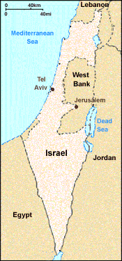
Drought Focuses Attention on Long-standing Water Disputes in the Middle East Drought Focuses Attention on Long-standing Water Disputes in the Middle East April, 1999 West Bank, Israel In the politically charged Middle East, water is one of the most important political issues, and one that is gaining in significance. Sharing scarce water resources between Israel and its neighbors has always been a source of conflict. This year tensions are growing sharply, as 1999 promises to be one of the driest in Israel's history. Sorting out water rights and allocations will test the strength of recent peace accords, and commitments to preserve peace, in the region.
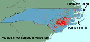
Recent peace accords between Israel and Jordan and the Palestinians have detailed water allotments that Israel must provide to the West Bank and to Jordan. The Palestinian allotments of 30 million cubic meters provides only about a third as much water per capita as that used by Israelis. The newly independent Palestinian state desperately needs this water and more if it is to develop an independent economy, and an improved standard of living for its growing population. Many Palestinian towns in the West Bank have no running water; others have irregular supplies and endure hot summer days with no incoming water supplies. Israel also has agreed to send 55 million cubic meters of water to Amman, Jordan. The Israeli government has tried to press to reduce allotments to both Jordan and Palestinians, but any reductions could seriously test peaceful relations. Israelis recognize that staying by the agreement is necessary to preserve peace. Meanwhile water allotments to farmers have been reduced. But ultimately more water is needed. Expensive, energy-consuming desalination plants may be the only solution in the long run. For further information, see these related sites: Core issues in the Palestinian-Israeli water dispute Water issues in the Arab-Israeli conflict Water research and management issues, from Technion University, Haifa, Israel To read more, see Environmental Science, a Global Concern, Cunningham and Saigo, 5th ed. Environmental Science, Enger and Smith, 6th ed. NC Aquatic Dead zone from floods after Hurricate Floyd October, 1999 Eastern North Carolina North Carolina, the US' leading hog producing states, is also home to the nation's highest concentration of hog manure-holding lagoons in a flood plain. In October 1999 those lagoons washed out in the flooding following Hurricane Floyd. The waste, mixed with the floating bodies of between 30,000 and 100,000 dead hogs, and with waste from flooded sewage plants, choked coastal rivers and washed into Pamlico and Core Sounds. There the waste created a 350-square mile dead zone, devoid of oxygen and of life, in the nation's second largest estuary. The state's $1 billion fishing industry is expected to suffer severely as a result of the flooding.
No one was surprised when the manure lagoons washed out. Statistically, North Carolina receives heavy rains and flooding after hurricanes as often as any other state on the eastern seabord. At the same time, the state has had explosive growth in the hog producing industry, producing 10 million animals a year by 1999. Many of the hog producers are located on the flat, flood-prone coastal plains and the river flats of eastern North Carolina. Environmental regulations on waste management are relatively lenient. Hogs are raised in barns holding thousands of animals each-many farms produce more waste than a small city. Each of these farms would warrant a full-scale sewage treatment facility if it were a city. Because these facilities are agricultural, though, they are overseen by the Department of Agriculture, which requires little or no processing or purification of waste materials. Liquid manure is normally spread on fields, where growing vegetation, ideally, takes up the excess nitrogen before it washes into groundwater or surface waterways. Every year there are dozens of significant lagoon spills, some of which have resulted in major fish kills. The floods after Floyd were only the most recent and most serious in a long series of lagoon spill catastrophes. In addition to the hogs killed in the floods, about 2 million chickens and 700,000 turkeys were drowned in the aftermath of Floyd. The governor of North Carolina has asked Congress for $5.3 billion in disaster relief aid, to rebuild hog barns and lagoons on the coastal plain as well as to help rebuild houses in the area. To read more, see Environmental Science, A Global Concern, Cunningham and Saigo, 5th ed.
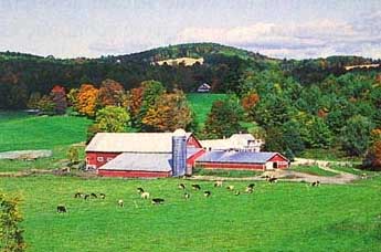
Environmental Science, Enger and Smith, 6th ed. For further information, see these related web sites: Report from the Washington Post Hog Watch: Environmental Defense Fund information on hog farming Report on the flood from Disaster Relief Watershed Protection in the Catskills New York City has long been proud of its excellent municipal drinking water. Drawn from the rugged Catskill Mountains 100 km (60 mi) north of the city, stored in hard-rock reservoirs, and transported through underground tunnels, the city water is outstanding for so large an urban area. Yielding 450,000 m3 (1.2 billion gal) per day, and serving more than 9 million people, this is the largest surface water storage and supply complex in the world. As the metropolitan agglomeration has expended, however, people have moved into the area around the Catskill Forest Preserve, and water quality is not as high as it was a century ago. When the 1986 U.S. Safe Drinking Water Act mandated filtration of all public surface water systems, the city was faced with building an $8 billion water treatment plant that would cost up to $500 million per year to operate. In 1989, however, the EPA ruled that the city could avoid filtration if it could meet certain minimum standards for microbial contaminants such as bacteria, viruses, and protozoan parasites. In an attempt to avoid the enormous cost of filtration, the city proposed land-use regulations for the five counties (Green, Ulster, Sullivan, Schoharie, and Delaware) in the Catskill/Delaware watershed from which it draws most of its water. With a population of 50,000 people, the private land within the 520 km2 (200 mi2) watershed is mostly devoted to forestry and small dairy farms, neither of which are highly profitable. Among the changes the city called for was elimination of storm water runoff from barnyards, feedlots, or grazing areas into watersheds. In addition, farmers would be required to reduce erosion and surface runoff from crop fields and logging operations. Property owners objected strenuously to what they regarded as onerous burdens that would cost enough to put many of them out of business. They also bristled at having the huge megalopolis impose rules on them. It looked like a long and bitter battle would be fought through the courts and the state legislature. To avoid confrontation, a joint urban/ rural task force was set up to see if a compromise could be reached, and to propose alternative solutions to protect both the water supply and the long-term viability of agriculture in the region. The task force agreed that agriculture is the "preferred land use" on private land, and that agriculture has "significant present and future environmental benefits." In addition, the task force proposed a voluntary, locally developed and administered program of "whole farm planning and best management approaches" very similar to ecosystem-based, adaptive management. Fig. 1. Investing in soil conservation and water-quality protection on small dairy farms and agroforestry programs within the Catskill/Delaware watershed has saved New York City billions of dollars in filtration costs and has also improved community relations.
This grass-roots program, financed mainly by the city, but administered by local farmers themselves, attempts to educate land owners, and provides alternative marketing opportunities that help protect the watershed. Economic incentives are offered to encourage farmers and foresters to protect the water supply. Collecting feedlot and barnyard runoff in infiltration ponds together with solid conservation practices such as terracing, contour plowing, strip farming, leaving crop residue on fields, ground cover on waterways, and cultivation of perennial crops such as orchards and sugarbush have significantly improved watershed water quality. As of 1999, about 400 farmers-close to the 85 percent participation goal-have signed up for the program. The cost, so far, to the city has been about $50 million-or less than 1 percent of constructing a treatment plant. In addition to saving billions of dollars, this innovative program has helped create good will between the city and its neighbors. It has shown that upstream cleanup, prevention, and protection are cheaper and more effective than treating water after it's dirty. Farmers have learned they can be part of the solution, not just part of the problem. And we have learned that watershed planning through cooperation is effective when local people are given a voice and encouraged to participate. International Accord to Clean Up the Rhine River April, 1999 Basel, Switzerland The Rhine River, which flows through some of Europe's biggest industrial districts, has long suffered from severe pollution, including chemical spills that have caused catastrophic fish kills. At times the water has been so contaminated that long stretches the river were emptied of living fish. In recent years several European governments have made special efforts to clean up and protect the Rhine. On April 12 conservation efforts moved forward with a new international convention (agreement) on the protection of the Rhine. Five countries signed the convention: Switzerland, France, Germany, Luxembourg, and the Netherlands (see map).
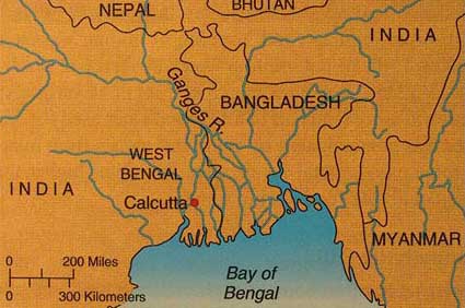
For further information, see these related sites: European Rivers Network homepage Description of the Rhine River, from the World Meteorological Organization To read more, see Environmental Science, a Global Concern, Cunningham and Saigo, 5th ed. Environmental Science, Enger and Smith, 6th ed. When we think of water pollution, we usually visualize sewage or industrial effluents pouring out of a discharge pipe, but there are natural toxins that threaten us as well. One of these is arsenic, a common contaminate in drinking water that may be poisoning millions of people around the world. Arsenic has been known since the fourth century B.C. to be a potent poison. It has been used for centuries as a rodenticide, insecticide, and weed killer, as well as a way of assassinating enemies. Because it isn't metabolized or excreted from the body, arsenic accumulates in hair and fingernails, where it can be detected long after death. Napoleon Bonaparte was found recently to have high enough levels of arsenic in his body to suggest he was poisoned. Perhaps the largest population to be threatened by naturally occurring groundwater contamination by arsenic is in West Bengal, India, and adjacent areas of Bangladesh. Arsenic, in the form of insoluble salts, occurs naturally in the bedrock that underlies much of this region. Under normal conditions, the groundwater stays relatively free of arsenic in a soluble form. Rapid population growth, industrialization, and intensification of agricultural irrigation, however, have put increasing stresses on the limited surface water supplies of this region. Groundwater has all but replaced other water sources for most people in West Bengal, especially in the dry season. In the 1960s, thousands of deep tube wells were sunk throughout the region to improve water supplies. Much of this humanitarian effort was financed by loans from the world bank in the name of human development. At first, villagers were suspicious of well water, regarding it as unnatural and possibly evil. But as surface water supplies diminished, dusty Bengali villages became more and more dependent on this new source of supposedly fresh, clean water. By the late 1980s, health workers became aware of widespread signs of chronic arsenic poisoning among villagers in both India and Bangladesh. Symptoms of chronic arsenicosis include watery and inflamed eyes, gastrointestinal cramps, gradual loss of strength, scaly skin and skin tumors, anemia, confusion, and, eventually, death. Why is arsenic poisoning appearing now? Part of the reason is increased dependence on well water, but some villages have had wells for centuries with no problem. One theory is that excessive withdrawals now lower the water table during the dry season, exposing arsenic-bearing rocks to air, which converts normally insoluble salts to soluble oxides. When aquifers are refilled during the next rainy season, dissolved arsenic can be pumped out. Health workers estimate that the total number of potential victims in India and Bangladesh may exceed 200 million people. But with no other source of easily accessible or affordable water, few of the poorest people have much choice. Although few places in North America have as high groundwater arsenic content as West Bengal, there are worries that millions of Americans also are exposed to dangerously high levels of this toxic element. In 1942, the U.S. Government set the acceptable level o arsenic in drinking water at 50 micrograms per liter (50 parts per billion or ppb). Although this standard was set before the connection between arsenic and cancer was understood, it has never been revised. Recent studies suggest that the risks of certain kinds of cancer from a lifetime of drinking water with 50 ppb of arsenic may be as high as 1 in 100, or 10,000 times the normally accepted threshold for acceptable risk. Repeated attempts to lower the standard to 10 ppb have been met with resistance from public officials and private water supply owners, who complain that it would cost too much to upgrade their systems. The government has no business, they maintain, in telling us what we can or cannot drink. Ethical Considerations What do you think? If you choose to drink water that gives you a 1 in 100 chance of cancer, is that your business or does the government have a right (or obligation) to stop you? Is it ethical to allow customers of water districts to be exposed to a poison that they know nothing about? Would it be enough to require public systems to inform their customers of the risks involved? Would your parents or friends understand the implications of 1 in 100 risk of cancer? Do they smoke? What could be done to help the hundreds of millions of people in India and Bangladesh who now drink contaminated water? Is it our responsibility? What if it was our money that installed the tube wells in the first place? Does that change the picture?
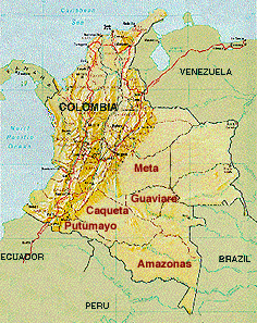
Colombia to Spray Coca Cops with Stronger Herbicide June, 1998 Environmental Consequences Could Be Severe After more than a decade of pressure, the Colombian government agreed in June to US demands to test a new herbicide for use in the war on cocaine producers. The new herbicide is tebuthiuron, a pelletized herbicide that is more effective, persistent, and environmentally dangerous than herbicides used in Colombia in the past. Critics, including a US General Accounting Office report of February 1998, argue that this new offensive is taking place at the expense of other, possibly more effective, interdiction efforts. For four years Colombian police have used airplanes to spray fields with liquid herbicides. But several problems have made these treatments relatively ineffective. Applications by air frequently miss target plants, or reach only parts of targeted fields, so that only about 30% of treated plants are killed. Rainfall quickly disperses and dilutes liquid herbicides, further reducing effectiveness. Most important, applications must be done low to the ground, at times of day when there is no rain and little wind to cause drift from the target fields. These low-level applications in fine weather make airplanes especially vulnerable to attack from the ground.
In contrast, tebuthiuron comes in pea-sized solid pellets, which can be dropped from higher altitudes even in rainy or windy weather. This makes tebuthiuron applications much safer for pilots. The solid pellets are expected to hit target fields with better accuracy, increasing the effectiveness of applications. Pellets break down and disperse more slowly than liquid herbicides, making the application more likely to kill plants. At the same time, tebuthiuron, which is sold in the United States under the brand name Spike, is a highly toxic, extremely persistent, broad-spectrum herbicide. Labels warn that even slight exposure to roots can kill trees. Persistence means that the chemical compound breaks down slowly, so that the herbicide can remain potent for 15 months. In a moist environment, such as in the rain forests of southern Colombia, water can quickly carry persistent herbicides through the environment. Broad-spectrum herbicides are lethal to a wide variety of vegetation. Tebuthiuron is effective not just against coca plants but also against any broadleaf or woody vegetation--including mature trees, shrubs, and vines. Environmentalists and members of the Colombian government worry that the persistence of the herbicide will make fields useless for subsistence agriculture after the coca plants have been killed. The region's peasants rely on subsistence farming in the forest for survival. Damage to forests surrounding coca fields could be extreme. And further deforestation is inevitable as coca growers--and subsistence farmers--are forced to clear more land for farming after tebuthiuron applications. Fears of Herbicide Persistence, Water Contamination One of the most urgent worries, though, is water contamination. The persistent herbicide moves and disperses quickly once it enters streams or groundwater. Although the herbicide is designed to kill plants, it is also poisonous to animals, and dispersal by water poses serious health threats to local farmers and to wildlife. The maker of tebuthiuron, a subsidiary of Dow Chemical Company, insists that the chemical be used only under carefully controlled conditions and where there are no nearby water bodies, streams, or shallow groundwater. But uncontrolled conditions and heavy rainfall are precisely the reasons the US government has insisted on tebuthiuron's use on Colombia's cocaine fields. The company strongly opposes this use of the herbicide. If approved for use, tebuthiuron could be used on more than 80,000 hectares (nearly 200,000 acres), mainly in the southern provinces of Caqueta, Putumayo, Guaviare, and Meta. Some Illegal Use Already Underway? Reports have surfaced that covert tebuthiuron applications have been under way at least since last spring, long before the Colombian government agreed to its testing. Until July the chemical was strictly banned in the country, but early last spring farmers were reporting on finding pea-sized pellets in their fields--pellets that experts contend could only be tebuthiuron. Pellets were found in nearby subsistence food plots, as well as in illegal coca fields. To read more, see Environmental Science, A Global Concern, Cunningham and Saigo, 5th ed.
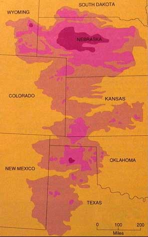
Environmental Science, Enger and Smith, 6th ed. The Ogallala Aquifer System is the largest known underground freshwater reservoir in the world. Lying under parts of eight states in the arid, high plains region, this reservoir has supplied water to one of the most important agricultural areas in he United States and has been a significant factor in the high rates of productivity we have enjoyed in recent years. However, the enormous amounts of water now being pumped out of the aquifer are depleting it much faster than it can be recharged from surface infiltration. In some areas, water tables are falling as much as 1 m (3 ft) per year. Many farmers are having to abandon irrigation, either because the aquifer has been exhausted under their land or because the costs of pumping from greater and greater depths are no longer justified by the crops produced. It is estimated that this vast aquifer once contained about 2,000 cu km (2 billion acre-feet) of water in porous rock layers, ranging in thickness from a few meters around the periphery of the formation to more than 400 m (1,200 ft) in the center of the pool under the sand hills of Nebraska. This is about sixteen times as much water as all lakes, streams, rivers, marshes, and other surface freshwater bodies on earth. Most of the water in the aquifer is thought to have been left by the glaciers that melted 15,000 years ago. In 1930, the average depth of the water was nearly 20 m (58 ft). In 1987, it was less than 3 m (8 ft) and falling. Some places are essentially out of water.
Exploitation of the high plains groundwater began about one hundred years ago when pioneer farmers and ranchers set up windmills for domestic supplies and to water crops and livestock. Although this early technology played a vital role in the settling of the American West, it had relatively little effect on the enormous amount of water contained in the aquifer. The real change came in the 1960s with the invention of center-pivot irrigation systems. In these systems, a high-capacity well drilled in the center of a field pumps water to large sprinklers that ride on a pipe up to 1 km (0.6 mi) long. The pipes are carried on motor-driven wheels in a huge circle around the well. Because the pipes have flexible joints and the wheels are driven independently, the whole apparatus can traverse hilly land that could not be irrigated by conventional gravity-fed methods. The amount of irrigated land on the high plains jumped from about 1 million ha (2.5 million acres) in 1950 to 6.5 million ha (16 million acres) in 1980. More than 150,000 wells supplied the water for about 33 percent of all cotton, 50 percent of all grain, and 40 percent of all beef produced in the United States in the early 1970s. At the peak of irrigation, more water was being drawn out of the aquifer each year than the entire annual flow of the Colorado River. In contrast to surface waters, which are tightly controlled by water laws and appropriation rights, there are no limits on how much water a person can pump from the ground, even though it is a shared resource that underlies neighboring land as well. There also are no regulations about how and for what purposes the water can be used. The rule was, and still is, "Those who pump fastest, get most." What will happen when the aquifer runs dry? Farmers may have to return to dry land farming that typically yields only one-third as much per unit of land as irrigated field. Alternative sources for municipal and industrial water supplies often do not exist. Cities may become ghost towns unless water is brought in from elsewhere. Pressure undoubtedly will rise for water transfer projects that can ship water from the Great Lakes states or the Mississippi River valley. The costs of those projects would be billions of dollars and the price of water delivered might be ten times what farmers comfortably can pay. Should the government bear some or all of those costs? Another interesting question is whether the areas that have plentiful water supplies should share their water. Many of the states that have lost industry and agricultural production in recent years to the western states might prefer that people and businesses move back to where the water is, rather than moving the water to where the people and businesses are. Where millions of dollars are invested in farms and communities, however, there are also human considerations. Should society have restricted population growth in areas where water has always been limited? Could we have foreseen the implications of water overdraft? What can we learn from this situation about the future use of water? |